The Yellow Chief Uranium Mine


What a great location! The mine is secluded, and loaded with excellent specimens!


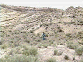
This shot was taken looking north.


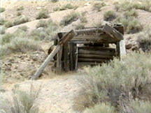
Some of the best quality uranium came from the pile
to the left of this wooden structure.


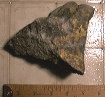
Here is some "Weeksite" ore.


I found this while digging in the earth with my rock hammer.
It was a startling experience!


See a zoom shot of the north wall
(Quicktime Movie 166k - No Sound)


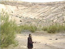
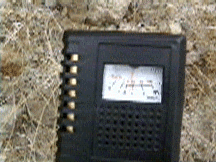
We were getting high readings from the mine dump piles!
(Quicktime Movie 180k - Sound)


Yellow Chief Uranium Mine, Juab County, Utah

Ben Bowyer

U.S. Atomic Energy Commission

From "Guidebook To The Geology of Utah" Number 17, 1963


The Yellow Chief Mine is in sec. 36, T. 12 S., R. 12 W., central Juab County, Utah, 50 miles by road northwest of Delta, Utah, the nearest supply point. The mine is at an attitude of 5,750 feet in a sparsely vegetated valley separating Spor Mountain to the west from the Thomas Range to the east.

In 1953, uranium was found on surface exposures near the site of the present open pit by private prospectors using hand-held radiation detectors. Following the discovery, the Yellow Chief group of claims was located, and shallow excavations were made exposing uraniferous material. Several small shipments of ore resulted from the early exploration. In 1955, the claims were leased to a mining company which outlined the ore zone by rotary drilling but later relinquished its lease.

The Topaz Uranium Company next leased the Yellow Chief claims and began its operations by stripping a small area along the southeast margin of the present workings. minable amounts of ore were found at grades exceeding those indicated by the drilling program.

This encouraged the company to test the ore zone underground, and, in 1959 the stripping and mining that has developed into the open pit, was started. In June 1962, the pit was 1,200 feet long, 300-500 feet wide, and 100-150 feet deep.

Structure


The open pit is on the north flank of a west- to southwest-plunging anticline. The beds in the north part of the pit strike N. 40 degrees E., and dip 35 degrees NW.; southward the attitudes gradually change to northwest strikes, and dips average 15 degrees SW. South of the pit proper, the host rocks strike west-northwest and dip 10-15 degrees.

Several hundred yards farther west, in a gully now filled with waste, the rocks have a similar strike, but dip north, suggesting a synclinal counterpart of the anticline.

Stratigraphic relationships indicate that the folded host rock has been faulted down at least several hundred feet relative to adjacent, older volcanic rocks. One of the faults along which the movement occurred is exposed in the northwest side of the pit. It strikes N. 30 degrees E., dips 40-50 degrees SW., and its footwall is a crystal tuff. Drag folding in the host rock on the hanging wall suggests normal movement. This fault is probably a primary control in the positioning of the Yellow Chief deposit, because it either (1) served as a conduit for solutions entering the host rock, (2) coupled with the crystal tuff, acted as a clam along which the mineralizing solutions collected, or, (3) more likely, is a post-ore fault which offset previously formed ore. Evidence Gained from the examination of surface exposures and drill-hole cuttings points to the existence of a subparallel fault about 1,000 feet to the southeast, which limits the host rock in that direction.

Two sets of minor faults, of northeast and northwest trends, are exposed in the pit walls and in places have offset ore lenses The movement along all but several of the faults has been normal and generally of 10 feet, or less. The northeast-striking set commonly dips 55-85 degrees NW., although southeast dips have been measured. The faults which strike northwest are about equally divided between those which dip southwest and those which dip northeast; in either direction the dips range from 60 to 88 degrees. Several east-west faults of small displacements are also noted.

ORE DEPOSIT


The Yellow Chief Mine, including its mined and developed ore, ranks with those uranium deposits containing over 100,000 tons of ore. The amount of ore in individual uninterrupted layers ranges from a few tens of tons to several thousand tons. The grade of the ore is erratic and varies not only for individual ore bodies but also laterally and vertically within a single body. Generally, an attempt is made by the company, through controlled mining and stockpiling, to maintain a shipping grade of between 0.20 and 0.23 percent U3O8.

Beta-uranophane, a pale to orange-yellow uranyl silicate (Ca(UO2)2(SiO3)2(0H)2*5H2O) is the only known uranium mineral in the zone. It fills pore spaces in sandstone and conglomerate and coats individual particles. Weeksite, a newly identified potassium uranyl silicate, occurs in a limestone conglomerate overlying the tuffaceous sandstone host rock, and shroeckingerite has been noted in veintets in a nearby pit (Outerbridge, Staatz, Mayrowitz, and Pommer, 1960).

In places brown and red iron oxides, associated with the uranium stain the host rock in streaks that commonly parallel stratification. Several areas of more intense ferruginous alteration, some slightly radioactive, are present south of the pit, but their significance is unknown as the iron oxides are not necessarily a guide to ore. A non-radioactive mineral having the same general appearance in outcrop as beta-uranophane has been tentatively identified as jarosite (?) it is disseminated in the host rock-in many parts of the mine.

The deposit differs from many occurrences of uranium in fluvial beds in not containing carbonaceous matter, other uranium minerals in important amounts, or abundant iron sulfides. It is possible that extended oxidation has erased traces of carbon and primary uranium that once may have been present, and it is probable that the abundant secondary iron minerals were formed in part from once prevalent finely-divided pyrite. Manganese oxide, beryIlium, and small nodules of chert-like material are present in small amounts. Calcium carbonate mainly in the cementing material, averages 1 to 2 percent.

The ore is in numerous lenticular layers confined to a block of the host rock over 2,000 feet long and 500 feet wide and elongated N. 30 degrees E. The block is limited on its northwest and southeast sides by faults. The ore bodies vary considerably in size; the largest are over 300 feet long and in places greater than 20 feet thick They occur throughout the vertical extent of the host rock from the uppermost conglomerate to within a few feet of the underlying water-laid tuff. The dominant control for any particular ore body is stratigraphic, but in detail the uranium may cut across stratification. The thicker ore bodies are in coarse-grained, gritty sandstone which contains relatively few lenses of conglomerate. However, ore also has formed in lenses of conglomerate, particularly where the upper conglomerate bed is present, and in lower conglomerate beds extending to the northeast. Lenses of fine grained and shaly material are not favorable for ore accumulation.


On To The Autunite #8 Prospect and Bell Hill Mines!


Return to Uranium Minerals


Return to Main